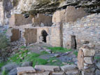
There are three major sets of ruins in Pueblo Canyon, arranged like multi-story apartment blocks along a shelf halfway up the canyon wall. Any of the three would be worth the trip by themselves: together they form an intriguing and picturesque group. This mosaic was taken in March of 2008, from across the narrow canyon. Ruin one is on the left, two is in the middle, and three is on the right.
As is the case with the majority of cliff dwellings, these are built into the north side of the canyon (facing south) so as to maximize the amount of sun exposure. However, access to the ruins up the north cliff face is virtually impossible. To get there, one must climb approximately 1500 feet up the slope below the south wall of the canyon to an altitude level with the ruins. At that point there is a shelf, which runs all the way along the south wall to the head of the canyon, and then back out the north side to the ruins. This route provides some surprises and some challenges. Although the canyon is over two miles long, it is only four or five hundred yards wide at the level of the shelf. Hiking in along the south wall therefore brings you directly opposite the ruins on the north side, which provides the view seen in the mosaic above. At the head of the canyon, the trail passes behind a waterfall that cascades off the top of the mesa (photos 14 and 15). During the rainy season, the amount of water coming over the falls can be substantial.
Under the category of "challenges," there are places where the ledge is not much wider than a sidewalk: You can literally stand with one hand touching the cliff face and the other suspended over a hundred feet of air. Also, during the winter, spray from the falls can coat the trail with ice. One of my hiking companions has (jokingly) proposed that the reason the ruins were only occupied for seventy years is that none of the Anchan children survived to adulthood.
One of the unusual aspects of this set of ruins is the pictograph shown in Photo 6. Although petroglyphs are quite common throughout Arizona, pictographs are fairly rare, and are usually found on rock surfaces that are protected from the environment. In this case, however, the pictographs are painted over the mud plaster that covers the inside of one of the structures. This is extremely rare.
A Word of Caution:
Due to the washout of Cherry Creek Road at Devil's Chasm, access to the ruins is more difficult than it used to be. In 1998 the hike to this site was about eight miles round trip. Today (March of 2008) it is two-and-a-half miles longer, which has substantially reduced the number of visitors. The trail is dim and hard to find and follow, and has become overgrown with manzanita, which makes for difficult hiking. If you go, realize that you are in a very remote and rugged area.


