The Roger's Canyon cliff dwelling is located halfway between Phoenix and Globe, in the middle of the Superstition Wilderness. It was built by the Salado—a culture related to the Hohokam—who inhabited the Tonto Basin from about 1150 to 1450 AD. This particular site once contained about 65 rooms and storage areas, and probably housed as many as 100 people. Most of the site has been destroyed by a series of historical inhabitants, pothunters, archaeological research projects, and hikers. Nevertheless, this is still one of the best-preserved cliff dwellings in the area.
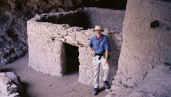
The ruins are built into a series of small caves that are formed in volcanic tuff, which is rough, crumbly and razor sharp. ("Tuff" is fragmented rock formed from volcanic detritus, such as ash and cinders.) Photo 1 shows an overview, and photo 2 shows a cross-the-canyon shot of two of the caves, with parts of ruins visible in both. The largest and most well preserved ruin is in the upper cave (title photo). After six hundred years, the original wooden lintel still supports the wall over the doorway into the open courtyard. The right-hand part of the structure has a roof made of logs overlaid with sticks and covered in mud. The end of one of the roof support beams, nine inches in diameter, is visible sticking out of the front wall about two feet down from the top. The first time I visited this ruin the roof was completely intact. By the time this photo was taken (2002), the roof had started to collapse, presumably damaged by careless hikers walking on it.
This site is clearly visible from the popular Roger's Canyon Trail, and its location has been published in several local hiking books, such as Dave Wilson's Ruins Seldom Seen and Scott Warren's 100 Hikes in Arizona; so there seems little point in trying to keep its location secret. To get there from Phoenix, take U.S. Highway 60 East about three miles past Florence Junction. Turn left (northwest) on Queen Valley Road for another two or three miles. Then turn right on Forest Road 357. This is a dirt road: from this point on, a high-clearance vehicle is recommended. Follow FR-357 for three miles, then turn left on FR-172 and go for 19 miles. When FR-172 changes to FR-172A, go another four miles (it is very steep) to the trailhead.
The hike itself is about four miles one way. There are several trails in the area, so make sure you have a map. From the parking area, start out on the Reavis Ranch Trail (Trail 109). You will pass the junction to West Pinto trail, which branches off to the right (don't take it). About 1.25 miles from the trailhead is the junction between Reavis Ranch Trail (which goes right) and Roger's Canyon Trail (which goes left). Follow Roger's Canyon Trail (Trail-110) as it follows the stream in the bottom of Roger's Canyon. The canyon is narrow, and the trail frequently crosses back and forth over the stream, but the hiking is relatively easy. The ruins are on the right, about four miles from the parking area. Half a mile beyond the ruins the canyon opens up into Angel Basin, a large meadow where several major trails intersect.
| Trail head | 33o 25' 16" N | 111o 10' 25" W |
| Junction, Reavis/Roger's trails | 33o 26' 22" N | 111o 11' 07" W |
| Ruins | 33o 27' 52" N | 111o 12' 28" W |


